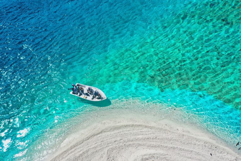
If you are passionate about nature and want to fully enjoy it while exploring on foot, Maremma is the right place for you. Hiking in this territory means entering in full contact with the natural elements , along a path of reconciliation between body and mind which takes place in the most remote corners of our mother land. Along these walks one can spot specimen of the local species, taste the typical products of this area and admire not only its landscapes but also the cultural evidence that the ancient civilization left in this land, so rich in tradition and history. There are many itineraries to follow. One can follow the trails left by the Etruscans, but also venture to discover the nature and the many animal species that populate this area, by visiting the Parco dell’Uccellina Natural Park, or by exploring the hidden coves of the Bandite di Scarlino Nature Reserve. Bandite di Scarlino Natural area From Scarlino to the necropolis of Poggio Tondo A 12 km itinerary of great environmental and historical interest connects the town of Scarlino to the Etruscan area of Poggio Tondo. The path begins right by the castle of Scarlino, then crosses a chestnut tree grove and goes uphill to the top of Mount d’Alma. The section going downhill leads to Fosso di Santa Lucia, and later proceeds to the valley of torrent Rigo. Continuing westwards along a wide dirt road, one reaches the Etruscan necropolis of Poggio Tondo: one of the archaeological areas located on the hills surrounding the valley of torrent Alma, where excavations uncovered one of the most ancient Etruscan settlements of the entire Maremma, dating from the 7th-6th century BC. The archaeological area of Poggio Tondo is composed of 4 burial mounds and the ruins of a Etruscan farm dated 6th century BC. From Scarlino to Portiglioni This trail, as the previous one, begins by Scarlino’s castle and proceeds across a dense chestnut tree grove. Leaving the trail that leads to the above mentioned Poggio Tondo to the left hand side, this itinerary goes up towards the area that includes Fosso Fedeli and Fosso dell’Uccelliera. Once it reaches a pass at the foot of Monte di Muro, the trail continues along the mountain ridge leading to Poggio Scodella, where one can admire the view over the Tyrrhenian Sea and the island of Elba. This itinerary is rather challenging and it is quite long, as it entails 10km of intense walking. From Portiglioni to Torre Civette and Punta Ala 11km-long, this is among the most classical itineraries of this coastal area. The itinerary follows the dirt road that runs along the enchanting beaches of Cala Francese, Cala Martina, Cala Violina and Cala le Donne. A few minor trails lead to panoramic spots where breathtaking views over the gulf and the nearby islands can be enjoyed. The trail ends at Punta Ala, which is only accessible from the beach or from the pine grove. From Torre Civette to Portiglioni via Val Martina Forming part of the previous itinerary, this trail forms a beautiful path that runs in a circle of approximately 9km, along which several farmsteads are to be spotted and the dense groves of Poggio Moscatello are to be walked through, while spotting Val Martina on the right hand side. After looking over the shore, the path goes back heading to the right in the direction of Poggio la Guardia, on a dirt road that crosses the main road via delle Collacchie and finally gets to the area of Portiglioni. From Val Martina to Cala Violina The shortest and thus among the busiest itineraries within the Bandite di Scarlino area, this trail is only 3.5km long and it begins by the state road via delle Collacchie (where the signs leading to Cala Violina are). This follows a dirt road that runs across the pine grove and part of the characteristic Mediterranean scrub that surrounds this zone. The trail arrives at the small natural oasis that is Cala Violina, among the most beautiful beaches in Tuscany and in Italy as a whole, famous for its “singing” sand, which in fact makes a sound similar to that of a violin. Archaeological hiking Some interesting hikes represent the perfect combination of natural environment and archaeology. They let visitors understand the origins of this region, as they run along the Etruscan sites of upper Maremma: Lago dell’Accesa, Roselle and the ancient Vetulonia. The archaeological area of Lago dell’Accesa is located merely 7km away from Massa Marittima, and it spans across a few dozen hectares that can be explored on foot, by bike or even on horseback for those who wish. Here five old residential districts were uncovered, to which five necropolises were supposed to correspond, partially identified by archaeological excavations. The ancient name of the settlement of Accesa is not known, what is known is that it probably was a satellite town of a bigger town, to be identified with Vetulonia, which at that time controlled the mineral deposits of the Colline Metallifere. The new Civic Museum at the core of the town of Vetulonia, dedicated to Isidoro Falchi, is the ideal starting point for those who wish to visit the archaeological area further downhill. The archaeological site of the old town of Roselle is located about 10km from Grosseto: this area lies along the shores of the ancient Lake Prile, in what used to be the territory ruled by the lucumo of central Etruria. The town has preserved an overlapping of buildings and defensive walls deriving from the succession of the Villanovan, Etruscan and finally Roman civilization. . . . .
.
.
. . . .
.
.
. . . .
.
.
. . .
.
. .
.
. .
.
.
.
. .
.
. .